Quy hoạch tỉnh Bà Rịa Vũng Tàu
Ba Ria – Vung Tau is a coastal province in the Southeast of Vietnam. This place emerges as a potential economic region, converging enough factors to become a satellite megacity of Ho Chi Minh City, helping to increase the population, infrastructure and social tension of the city in the northeast region. decrease. The synchronization of 4 traffic routes Thuy – Ministry – No – Iron is an important highlight of this area.
A brief introduction about Ba Ria – Vung Tau
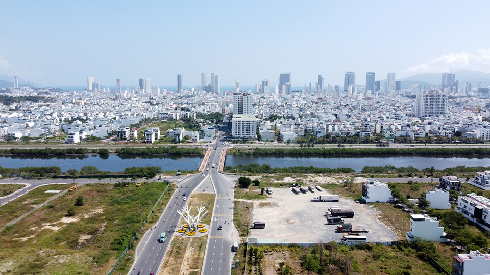
Previously, there were only 2 main roads from Ho Chi Minh City to Vung Tau. The first road from National Highway 1A to Vung Tau T-junction, then turn right onto Highway 51 to go straight to Ba Ria – Vung Tau. The second option is to take the Cat Lai Ferry to Nhon Trach, then follow the 25B road to National Highway 51 and then go straight to Vung Tau city. In 2015, the expressway Ho Chi Minh City – Long Thanh – Dau Giay was completed, reducing the distance and travel time between the two provinces.
Vung Tau, a coastal tourist city and oil production center of the South, was once the administrative center of the province. On May 2, 2012, the provincial capital moved to Ba Ria city. This is also the first province in the Southeast to have two cities under the province.
In 2018, Ba Ria – Vung Tau was Vietnam’s 38th largest administrative unit in terms of population, 7th in terms of gross regional product (GRDP), 3rd in terms of gross domestic product and GDP per capita. 47th. With 1,112,900 people, GRDP reached 149,574 billion VND in the oil and gas industry according to the regulations of the General Statistics Office (Vietnam).
According to 2004 data of the United Nations Development Program in Vietnam, Ba Ria – Vung Tau is the leading province in the country in terms of GDP per capita (USD 10,543 in terms of purchasing power parity) and in terms of development index. . 0.828.The province has a high urbanization rate of 61.9%.
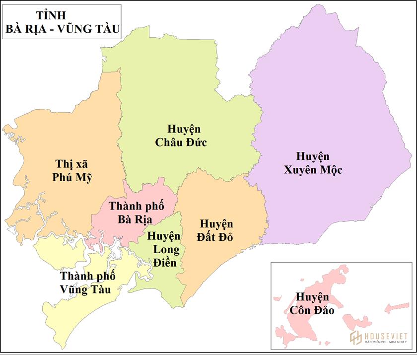
Administrative unit of Ba Ria Vung Tau province
Ba Ria – Vung Tau province has 8 district-level administrative units, including 2 cities, 1 town and 5 districts with 82 commune-level administrative units, including 29 wards, 6 townships and 47 communes.
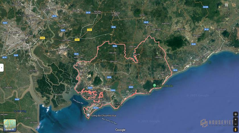
Geographical location Ba Ria – Vung Tau Province
- To the north, it borders Dong Nai province.
- The West borders Ho Chi Minh City.
- The East borders Binh Thuan province and the East Sea.
- The South borders the East Sea.
Ba Ria – Vung Tau is located in the southern economic region and is one of the places with potential to develop projects in the field of tourism, services, real estate and industrial. With diverse connection infrastructure such as:
- The expanded National Highway 51 will help improve and shorten the route from Ho Chi Minh City to Ba Ria – Vung Tau.
- National Highway 55 connects the provinces of Ba Ria – Vung Tau, Binh Thuan, Lam Dong
- National Highway 56 connects Ba Ria city, Ba Ria – Vung Tau province with Dong Nai.
- Bien Hoa – Vung Tau Expressway and Xuyen A Expressway
- Tunnel through the sea between Can Gio and Vung Tau
- Highway 5 coastal route from Binh Chau (Ba Ria – Vung Tau) – La Gi – Ham Thuan Nam – Phan Thiet – Bac Binh to Tuy Phong (Binh Thuan) via National Highway 1A.
Near industrial parks – large urban areas such as: Phu My Industrial Park, Chau Duc Sonadezi Industrial Park, Da Bac Industrial Park, Dat Do Industrial Park, Hoa Long Industrial Park…
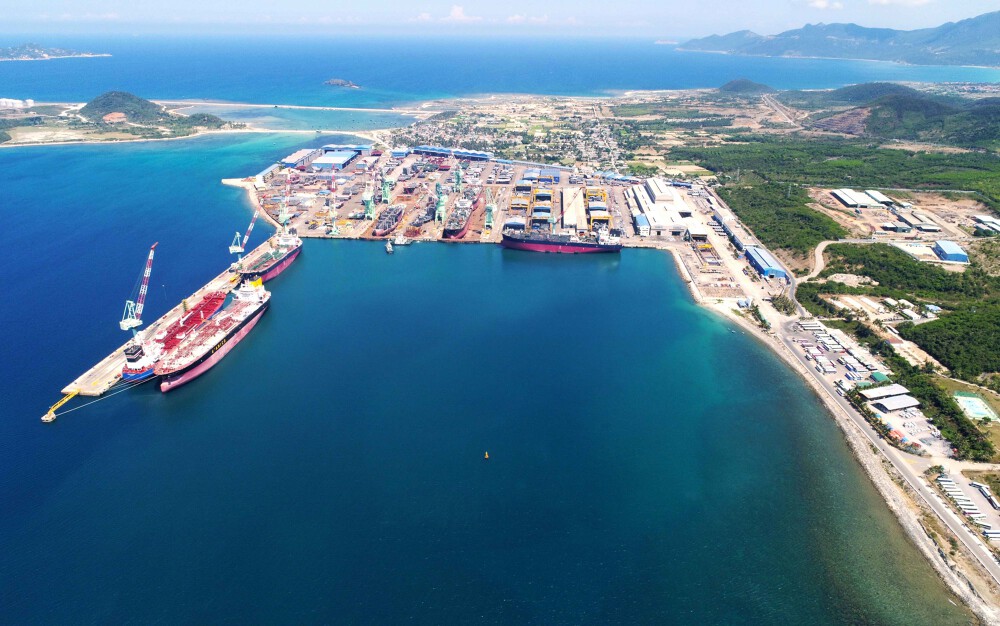
In addition, thanks to a system of more than 20 rivers and canals, many estuaries, and a large coastline, Ba Ria – Vung Tau is a very favorable place to develop a seaport. Thi Vai – Cai Mep port cluster is one of the 19 largest international ports in the world.
In addition, since moving Saigon and Ba Son ports and starting construction, Ba Ria – Vung Tau has become the largest logistics center in the Southeast region with 28/52 seaports in operation. This is an opportunity for Ba Ria – Vung Tau Province to develop.
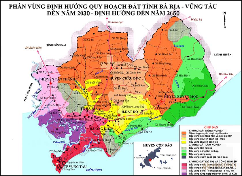
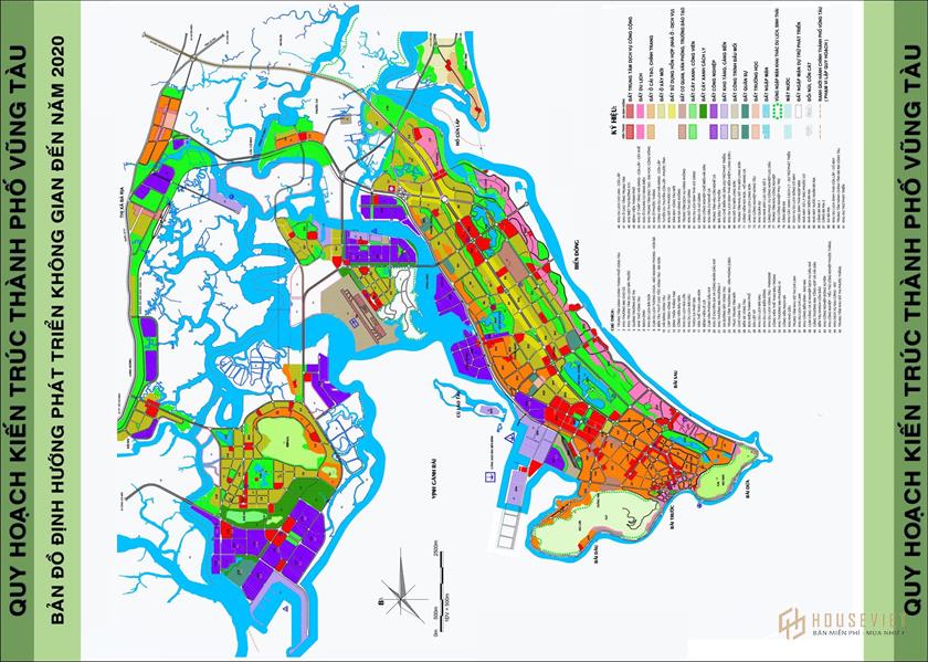
Planning Map of Ba Ria Vung Tau Province
Land planning of Ba Ria Vung Tau province to 2030 – orientation to 2050
According to the new plan, the area of Vung Tau will be expanded by more than 1,000 hectares compared to the old plan. 7 areas including Long Son Island, Go Gang, Bac Phuoc Thang, Industrial Park – Port, Existing Urban Area, North Vung Tau Area and Chi Linh – Cua Lap Coastal Tourism Development Zone.
In particular, Chi Linh – Cua Lap area will be developed into a mixed-use area with the main functions of resort tourism, entertainment, golf course, urban residential area, commercial services and open space. Areas connected to the sea space give priority to developing resort tourism, entertainment, squares and open spaces for the community.
The total land area of this area is about 1,114 hectares, of which urban construction land is about 1034 hectares, the proportion of land fund for tourism development, commercial services and lake space accounts for at least 50% of the urban area of the land. construct. The maximum population size is about 45,000 people.
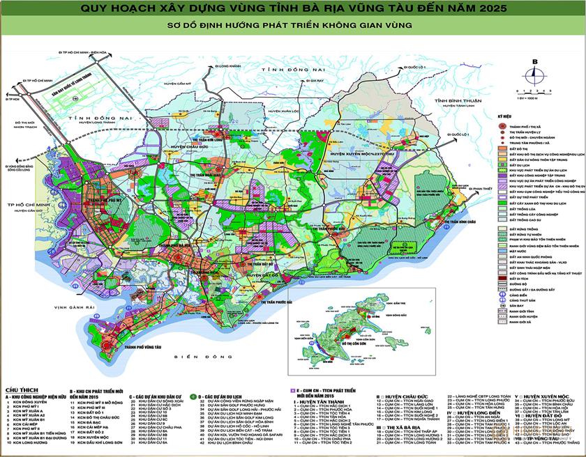
Traffic planning map of Ba Ria – Vung Tau province
Highlights in traffic system planning Ba Ria – Vung Tau province is the goal of forming 3 main port clusters to encourage exploitation and improve import-export development activities for the region. Three port clusters are planned as Ho Chi Minh City, Dong Nai and Ba Ria – Vung Tau ports, in addition to Cai Mep – Thi Vai, this port area will be developed into an international gateway of an important economic region. important.
With an investment of nearly 1 billion USD, 20 traffic works will be invested to complete and improve connectivity throughout Ba Ria – Vung Tau province and surrounding areas.
- Highway 56 connecting Long Khanh – Vung Tau
- Highway 51 connecting Ho Chi Minh City – Vung Tau
- Ben Luc – Long Thanh Expressway
- Road through Asia
- Bien Hoa – Vung Tau Expressway
- Project Ring Road 4 connects Ba Ria – Vung Tau with Trang Bom (Dong Nai) and Phu My (Tan Thanh).
- Underwater tunnel between Can Gio and Vung Tau
- Cau Chay Street, Nguyen Huu Canh, Hang Dieu, …
- Road 991B
- Provincial Road 328
- Ho Tram Airport, Con Son Airport, Go Gang Airport, Long Thanh International Airport
Infrastructure planning
Ba Ria – Vung Tau is oriented to develop into an economic center and a satellite town of Ho Chi Minh City. Especially with the potential for industrial – agricultural development, sea import and export, tourism, infrastructure planning is an extremely urgent issue for the development of the region in the future.
Some resorts and infrastructure investment in Ba Ria – Vung Tau:
- Ho Tram Safari of Novaland Investor, Vidotour
- Dinh Mountain Tourism Complex of FLC . Group
- Phu My Sports Park 3
- Building Bau Trung Park
- Bau Sen Park
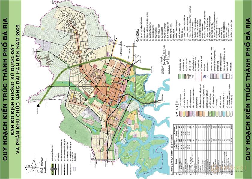
Planning of Ba Ria city
Ba Ria city is the administrative – political, economic, cultural – social center of Ba Ria – Vung Tau province. Being the nucleus in the urbanization process of Ba Ria – Vung Tau province.
Objectives of planning Ba Ria city
With the clear goal of developing into a class I city, all levels of government in the city Ba Ria has successfully implemented the key tasks set out from the beginning of 2018 to 2025.
- It is a commercial and service center of the province and sub-region.
- Being the center of education – training, scientific research of the province and sub-region.
- Has an important position in relation to national security.
Ba Ria city plays an important role in connecting the economic space between the industrial centers of the province, performing the task of providing products and services for industrial zones and at the same time supplying raw materials for other industries. neighboring district.
Planning map of Ba Ria city
About urban landscape architecture planning
The synchronous development of technical and social infrastructure must harmonize construction space and landscape space, develop sustainably and protect the environment, and develop Ba Ria city into a civilized city. Modern, bold national identity.
Sustainable development, with a green, clean and beautiful environment, bold landscape architecture typical of the Southeast region. Transforming Ba Ria city into an urban center with a centralized structure – an open space in the direction of planning – in order to re-affirm the role and position of the city in the region to create investment attraction; Urban Development.
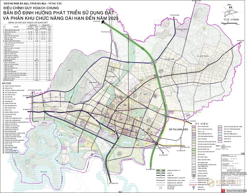
About the development of the city’s technical infrastructure system
Focus on investing in a number of key stages such as: Grounding of the entire electrical and optical cable system, investing in the construction of the Thu Luu box culvert system, upgrading and expanding. Cach Mang Thang Tam Street – the main street of the city center; focus on investing in inner-city traffic routes to accelerate socio-economic development and urban face such as: Tran Hung Dao, Vo Thi Sau, expanded Nguyen Tat Thanh street, the main road of Tan commune Hung stage 2.
Complete construction of a technical and infrastructure system of 1,680 ha in the new urban area combining eco-tourism in the southern area of the mangrove forest and form a new urban area south of National Highway 51, including the Technical floors. , Residential area, school, commercial area, …
In the field of socio-cultural development
Focus on implementing programs project socio-cultural development according to the resolution of Ba Ria City Party Committee as follows:
Project new rural construction,
Project to improve the quality of the title of Cultural city
Project on universalizing preschool for 5-year-old children; invest in building and modernizing schools to achieve the goal of 100% schools reaching national standards; Implement well the policy of “reciprocal gratitude”, policies to ensure social security.
Vung Tau city planning
Scope of planning Vung Tau city
Scope of setting zoning all inclusive Administrative area of Vung Tau city, Ba Ria Vung Tau Province, with a total area of about 15,043 ha. The specific limits are limited as follows:
- The East and South borders the East Sea and part of Long Dien district.
- The West borders Ganh Rai Bay.
- The North borders Ba Ria city and a part of Phu My town.
Planning goals of Vung Tau city
As an economic, cultural, public service center and an important exchange hub of the Southeast region, the southern key economic region and Ba Ria – Vung Tau province.
As a center of tourism, trade – finance – banking, seafood logistics services, maritime services, seaport development, oil and gas exploitation and processing across the country.
Has an important position in relation to national security and marine environment protection.
Traffic planning map of Vung Tau city
Road: Construction of Bien Hoa – Vung Tau expressway; Expanding National Highway 51 in the direction of regional traffic, connecting the city with other urban centers in the province and Ho Chi Minh City region.
Rail: To build the Bien Hoa – Vung Tau railway line in accordance with and in accordance with the development planning of railway transport in Vietnam. The scope and vacancies and individual stations correspond to the approved specialized plans.
Airline: Comply with the Vietnam Air Transport Development Plan and appropriate regional plans.
Inland waterways: to build an inland waterway port system according to the specialized traffic planning in order to effectively exploit the main routes on Dinh river; Mui Gioi River; Flow Rating; Cha Va River; Ba Coi River; Co May River – Cua Lap; Song Sao; Rach Tre and Rach Ben Dinh.
Seaway: to build and develop seaports according to specialized traffic plannings, synchronously with technical infrastructure systems of railways, roads and inland waterways. The main ports include: Sao Mai – Ben Dinh, Long Son, port on Dinh river and a system of passenger jetties and marinas on Dau and Front beaches.
Upgrading and embellishing the existing urban transport system. Continue to build, renovate and complete the vertical streets; Develop more horizontal axis network connecting the central area with the coastal area. The proportion of land for traffic, static traffic and urban road network corresponds to current regulations, standards and criteria of urban grade I in force.
Public transport: develop a bus transportation system to meet urban needs and connect with neighboring areas. To focus on developing a bus network connecting urban areas and convenient connections to newly developed urban centers.
Above is all the information compiled by the House Viet editorial board and sent to you for your reference. For all detailed information about the planning, we encourage you to go directly to the administrative agency to confirm before making related transactions.
Follow House Viet Editor | synthetic
houseviet.vn